CURRENT AFFAIRS
Get the most updated and recent current affair content on Padhaikaro.com
Kalapani Dispute in Uttarakhand
- IAS NEXT, Lucknow
- 13, Oct 2021
Nepalese political parties have a general consensus over the fact that Kalapani in Uttarakhand is part of Nepal’s sovereign territory, said former Nepalese Foreign Minister. However, India rejected this claim.
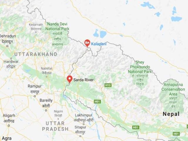
Where is Kalapani located?
Located in the easternmost corner of Uttarakhand’s Pithoragarh district.
- Shares a border on the north with the Tibet Autonomous Region of China and Nepal in the east and south.
- It is wedged in between Limpiyadhura, Lipulekh and Kalapani.
- The area is the largest territorial dispute between Nepal and India consisting of at least 37,000 hectares of land in the High Himalayas.
Who controls the area?
The area is in India’s control but Nepal claims the region because of historical and cartographic reasons.
What is the cause of the dispute?
The Kalapani region derives its name from the river Kali. Nepal’s claims to the region is based on this river as it became the marker of the boundary of the kingdom of Nepal following the Treaty of Sugauli signed between the Gurkha rulers of Kathmandu and the East India Company after the Gurkha War/Anglo-Nepal War (1814-16). The treaty was ratified in 1816.
- According to the treaty, Nepal lost the regions of Kumaon-Garhwal in the west and Sikkim in the east.
- According to Article 5, the King of Nepal gave up his claims over the region west of the river Kali which originates in the High Himalayas and flows into the great plains of the Indian subcontinent.
- According to the treaty, the British rulers recognised Nepal’s right to the region that fell to the east of the river Kali.
Present issues:
- According to Nepal’s experts, the east of the Kali river should begin at the source of the river. The source according to them is in the mountains near Limpiyadhura, which is higher in altitude than the rest of the river’s flow.
- Nepal claims that a land mass, high in the mountains that falls to the east of the entire stretch starting from Limpiyadhura downwards, is theirs.
- India on the other hand says the border begins at Kalapani which India says is where the river begins.
- The dispute is mainly because of the varying interpretation of the origin of the river and its various tributaries that slice through the mountains.
- While Nepal’s claim of the territory east of Kali is based on the Limpiyadhura origin, India says the river actually takes the name Kali near Kalapani.
What is the current position?
- Nepal has published a revised official map incorporating the territory from the Limpiyadhura source of the Kali to Kalapani and Lipulekh pass in the northeast of the triangular region as its territory.
- Last year, the Cabinet led by Prime Minister K.P. Sharma Oli registered a constitution amendment motion to grant constitutional status to the map.
- Indian observers say this move makes any future solution on the Kalapani issue nearly impossible as a constitutional guarantee will make Kathmandu’s position inflexible.